IMAGES TAKEN NEAR TO
Old Watling Street, ROCHESTER, ME2 3UF
Introduction
This page details the photographs taken nearby to Old Watling Street, ME2 3UF by members of the Geograph project.
The Geograph project started in 2005 with the aim of publishing, organising and preserving representative images for every square kilometre of Great Britain, Ireland and the Isle of Man.

There are currently over 7.5m images from over14,400 individuals and you can help contribute to the project by visiting https://www.geograph.org.uk
Image Map
Images are licensed for reuse under creativecommons.org/licenses/by-sa/2.0
Notes
- Clicking on the map will re-center to the selected point.
- The higher the marker number, the further away the image location is from the centre of the postcode.
Image Listing (33 Images Found)
Images are licensed for reuse under creativecommons.org/licenses/by-sa/2.0
Image
Details
Distance
2
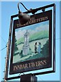
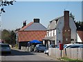
The Three Crutches sign
Sign for Image, an Innbar Taverns pub on Old Watling Street.
Image: © Oast House Archive
Taken: 28 Mar 2012
0.03 miles
3
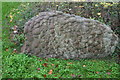
Sarsen stone, Old Watling Street, Strood
This stone and another stand near the corner of Old Watling Street and the A1. Sarsens were formed in Miocene times by a process of siliceous cementation within pre-existing strata of fine quartz sandstones. Whereas the sandstones were in due course eroded, the much harder sarsens have survived and are still to be seen in North Kent and in many other parts of south-east England. The matter of how this stone acquired its smoothly rounded, convex surfaces remains unresolved. Were existing mamillary concretions cemented together to form the configuration seen here or was the latter the product of a single episode of cementation?
Image: © David Kemp
Taken: 8 Nov 2015
0.04 miles
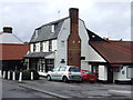
5
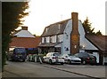
The Three Crutches
An Innbar Taverns pub on Old Watling Street.
Also see Image
Image: © Oast House Archive
Taken: 28 Mar 2012
0.06 miles
6

Roundabout on Watling Street A2
Seen from Old Watling Street (from Higham Village), A2 heading right, leads to the dual carriageway A2 leading to London/M25. A2 heading left, leads towards Strood and Medway towns.
Image: © David Anstiss
Taken: 20 Nov 2008
0.06 miles
8
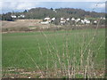
View from Crutches Lane
This view looks from Crutches Lane on the very edge of Strood to Gad's Hill on the outskirts of Higham. The very busy A289 runs through a cutting just beyond the field ahead.
Image: © Marathon
Taken: 14 Feb 2013
0.09 miles
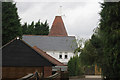
10
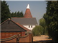
Crutches Farm Oast House
Part of Crutches Farm on Old Watling Street.
Image: © David Anstiss
Taken: 28 Jun 2010
0.10 miles