IMAGES TAKEN NEAR TO
Woodview Rise, ROCHESTER, ME2 3RP
Introduction
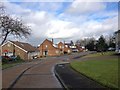
This page details the photographs taken nearby to Woodview Rise, ME2 3RP by members of the Geograph project.
The Geograph project started in 2005 with the aim of publishing, organising and preserving representative images for every square kilometre of Great Britain, Ireland and the Isle of Man.

There are currently over 7.5m images from over14,400 individuals and you can help contribute to the project by visiting https://www.geograph.org.uk
Image Map
Images are licensed for reuse under creativecommons.org/licenses/by-sa/2.0
Notes
- Clicking on the map will re-center to the selected point.
- The higher the marker number, the further away the image location is from the centre of the postcode.
Image Listing (31 Images Found)
Images are licensed for reuse under creativecommons.org/licenses/by-sa/2.0
Image
Details
Distance
10
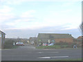
Brompton Farm
The historic map shows the farm, though the present one does not as it is surrounded by housing. It lies on the old A289 which has now been bypassed (the new road runs behind the farm).
Image: © Stephen Craven
Taken: 27 Jan 2007
0.10 miles