IMAGES TAKEN NEAR TO
Lynette Avenue, ROCHESTER, ME2 3NH
Introduction
This page details the photographs taken nearby to Lynette Avenue, ME2 3NH by members of the Geograph project.
The Geograph project started in 2005 with the aim of publishing, organising and preserving representative images for every square kilometre of Great Britain, Ireland and the Isle of Man.

There are currently over 7.5m images from over14,400 individuals and you can help contribute to the project by visiting https://www.geograph.org.uk
Image Map
Images are licensed for reuse under creativecommons.org/licenses/by-sa/2.0
Notes
- Clicking on the map will re-center to the selected point.
- The higher the marker number, the further away the image location is from the centre of the postcode.
Image Listing (28 Images Found)
Images are licensed for reuse under creativecommons.org/licenses/by-sa/2.0
Image
Details
Distance
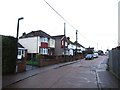
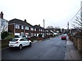
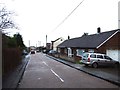
4
Brompton Farm Road, Strood
This used to be the A289 but was downgraded to the B2108 after being by-passed in the 1990s.
Image: © Chris Whippet
Taken: 15 Jul 2009
0.09 miles
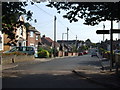
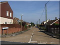
10
Cliffe Road, Strood (2)
The old canal tunnel, now a railway tunnel, is 40 or so metres beneath us here.
Image: © Danny P Robinson
Taken: 12 Jul 2008
0.15 miles