IMAGES TAKEN NEAR TO
Crusade Way, ROCHESTER, ME2 2ZG
Introduction
This page details the photographs taken nearby to Crusade Way, ME2 2ZG by members of the Geograph project.
The Geograph project started in 2005 with the aim of publishing, organising and preserving representative images for every square kilometre of Great Britain, Ireland and the Isle of Man.

There are currently over 7.5m images from over14,400 individuals and you can help contribute to the project by visiting https://www.geograph.org.uk
Image Map
Images are licensed for reuse under creativecommons.org/licenses/by-sa/2.0
Notes
- Clicking on the map will re-center to the selected point.
- The higher the marker number, the further away the image location is from the centre of the postcode.
Image Listing (34 Images Found)
Images are licensed for reuse under creativecommons.org/licenses/by-sa/2.0
Image
Details
Distance
1
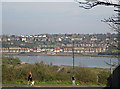
Site of Martin Earles cement plant, Strood
The Martin Earles cement plant operated between 1881 and 1967. For details, see www.cementkilns.co.uk/cement_kiln_martin_earles.html and related pages. In the later years, the plant was confined to the rough ground in the foreground. In the background are the riverside streets of Borstal.
Image: © Dylan Moore
Taken: 1 Apr 2014
0.05 miles
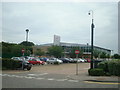
2

Virgin Active health club
On Chariot Way in the Medway Valley Leisure Park.
Image: © David Anstiss
Taken: 21 Jan 2014
0.06 miles
3
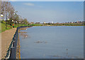
Wasteland leading to a Riverside Path
There is an unofficial path along the river here, but it's fenced off. Locals don't let it stop them, they just swing round the end of the fence to overhang the river edge for a short way, until they reach the other side. Adults, and children too.
Image: © Danny P Robinson
Taken: 20 Jul 2008
0.07 miles
4
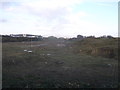
Derelict Area near Medway Valley Leisure Park
As seen from the roundabout on Chariot Way.
In the background (behind a row of trees along the Strood to Cuxton railway line) is the Royal Mail Sorting Office.
Image: © David Anstiss
Taken: 21 Jan 2014
0.07 miles
5
Virgin Active health club, Medway Valley Leisure Park
Image: © Stacey Harris
Taken: 13 Jun 2010
0.08 miles
6
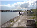
Martin Earles Wharf: high tide
See also Image The 700 m long wharf is all that now remains of the Martin Earles cement plant that operated here from 1881 to 1967. For more information, see www.cementkilns.co.uk/cement_kiln_martin_earles.html and related pages.
Image: © Dylan Moore
Taken: 1 Apr 2014
0.09 miles
7
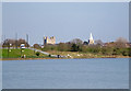
Site of Martin Earles cement plant, Strood
The Martin Earles cement plant operated here from 1881 to 1967. For more information, see www.cementkilns.co.uk/cement_kiln_martin_earles.html and related pages. The later rotary kiln plant was located in the rough ground at the far end of the wharf. Rochester castle and cathedral are behind, around the bend in the river.
Image: © Dylan Moore
Taken: 1 Apr 2014
0.09 miles
8
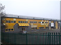
Empty yellow building
This industrial building beside Knight Road is looking for new tenants.
Image: © David Anstiss
Taken: 21 Jan 2014
0.11 miles
9
Martin Earles Wharf: low tide
The 700 m long wharf is all that now remains of the Martin Earles cement plant that operated here from 1881 to 1967. For more information, see http://www.cementkilns.co.uk/cement_kiln_martin_earles.html and related pages.
Image: © Dylan Moore
Taken: 1 Apr 2014
0.11 miles
10
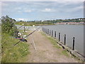
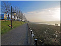
Riverside Path, Strood
By the River Medway, near the Medway Valley Leisure Park. The path ends soon, at the fence. It is high tide and the anglers are out.
Image: © Danny P Robinson
Taken: 20 Jul 2008
0.13 miles