IMAGES TAKEN NEAR TO
Lancelot Avenue, ROCHESTER, ME2 2YX
Introduction
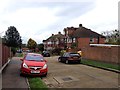
This page details the photographs taken nearby to Lancelot Avenue, ME2 2YX by members of the Geograph project.
The Geograph project started in 2005 with the aim of publishing, organising and preserving representative images for every square kilometre of Great Britain, Ireland and the Isle of Man.

There are currently over 7.5m images from over14,400 individuals and you can help contribute to the project by visiting https://www.geograph.org.uk
Image Map
Images are licensed for reuse under creativecommons.org/licenses/by-sa/2.0
Notes
- Clicking on the map will re-center to the selected point.
- The higher the marker number, the further away the image location is from the centre of the postcode.
Image Listing (21 Images Found)
Images are licensed for reuse under creativecommons.org/licenses/by-sa/2.0
Image
Details
Distance
10
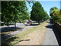
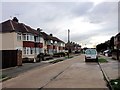
Watling Street near River Drive
With the M2 by-passing Strood it is easy to forget that Watling Street was once the main road between London, Canterbury and Dover. As can be seen here it was clearly wider in the past when it was the main road.
Image: © Marathon
Taken: 24 Jul 2013
0.18 miles