IMAGES TAKEN NEAR TO
Squires Close, ROCHESTER, ME2 2TZ
Introduction
This page details the photographs taken nearby to Squires Close, ME2 2TZ by members of the Geograph project.
The Geograph project started in 2005 with the aim of publishing, organising and preserving representative images for every square kilometre of Great Britain, Ireland and the Isle of Man.

There are currently over 7.5m images from over14,400 individuals and you can help contribute to the project by visiting https://www.geograph.org.uk
Image Map
Images are licensed for reuse under creativecommons.org/licenses/by-sa/2.0
Notes
- Clicking on the map will re-center to the selected point.
- The higher the marker number, the further away the image location is from the centre of the postcode.
Image Listing (32 Images Found)
Images are licensed for reuse under creativecommons.org/licenses/by-sa/2.0
Image
Details
Distance
5
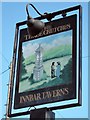
The Three Crutches sign
Sign for Image, an Innbar Taverns pub on Old Watling Street.
Image: © Oast House Archive
Taken: 28 Mar 2012
0.10 miles
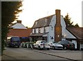
7
The Three Crutches
An Innbar Taverns pub on Old Watling Street.
Also see Image
Image: © Oast House Archive
Taken: 28 Mar 2012
0.10 miles
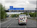
8
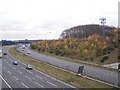
Mobile Phone Mast next to A2 / M2
From onramp bridge over M2. M2 heading south-east to Medway Bridge.
Behind Mast on right is Cole Wood which hides a covered reservoir.
Image: © David Anstiss
Taken: 20 Nov 2008
0.10 miles
10

Roundabout on Watling Street A2
Seen from Old Watling Street (from Higham Village), A2 heading right, leads to the dual carriageway A2 leading to London/M25. A2 heading left, leads towards Strood and Medway towns.
Image: © David Anstiss
Taken: 20 Nov 2008
0.11 miles