IMAGES TAKEN NEAR TO
Parkfields, ROCHESTER, ME2 2TN
Introduction
This page details the photographs taken nearby to Parkfields, ME2 2TN by members of the Geograph project.
The Geograph project started in 2005 with the aim of publishing, organising and preserving representative images for every square kilometre of Great Britain, Ireland and the Isle of Man.

There are currently over 7.5m images from over14,400 individuals and you can help contribute to the project by visiting https://www.geograph.org.uk
Image Map
Images are licensed for reuse under creativecommons.org/licenses/by-sa/2.0
Notes
- Clicking on the map will re-center to the selected point.
- The higher the marker number, the further away the image location is from the centre of the postcode.
Image Listing (30 Images Found)
Images are licensed for reuse under creativecommons.org/licenses/by-sa/2.0
Image
Details
Distance
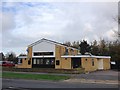
5
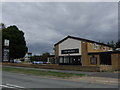
The Bounty
On Bligh Way, Strood. It does not appear to be a tied house. The inn sign shows a square-rigged ship, presumably HMS 'Bounty' commanded by Captain Bligh until the famous mutiny.
Image: © Robin Webster
Taken: 13 Jun 2012
0.11 miles