IMAGES TAKEN NEAR TO
Merrals Wood Road, ROCHESTER, ME2 2PR
Introduction
This page details the photographs taken nearby to Merrals Wood Road, ME2 2PR by members of the Geograph project.
The Geograph project started in 2005 with the aim of publishing, organising and preserving representative images for every square kilometre of Great Britain, Ireland and the Isle of Man.

There are currently over 7.5m images from over14,400 individuals and you can help contribute to the project by visiting https://www.geograph.org.uk
Image Map
Images are licensed for reuse under creativecommons.org/licenses/by-sa/2.0
Notes
- Clicking on the map will re-center to the selected point.
- The higher the marker number, the further away the image location is from the centre of the postcode.
Image Listing (24 Images Found)
Images are licensed for reuse under creativecommons.org/licenses/by-sa/2.0
Image
Details
Distance


10
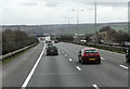
Descending Towards The Medway
The M2 motorway with the A228 bridge visible ahead. The Channel Tunnel Rail Link can be seen on the right. This is in the middle of Junction 2 of the M2 but little of the junction is visible to the passing motorist as it is below the level of the motorway and screened by fences and trees.
Image: © Martin Addison
Taken: 21 Mar 2015
0.17 miles