IMAGES TAKEN NEAR TO
Beech Road, ROCHESTER, ME2 2LP
Introduction
This page details the photographs taken nearby to Beech Road, ME2 2LP by members of the Geograph project.
The Geograph project started in 2005 with the aim of publishing, organising and preserving representative images for every square kilometre of Great Britain, Ireland and the Isle of Man.

There are currently over 7.5m images from over14,400 individuals and you can help contribute to the project by visiting https://www.geograph.org.uk
Image Map
Images are licensed for reuse under creativecommons.org/licenses/by-sa/2.0
Notes
- Clicking on the map will re-center to the selected point.
- The higher the marker number, the further away the image location is from the centre of the postcode.
Image Listing (34 Images Found)
Images are licensed for reuse under creativecommons.org/licenses/by-sa/2.0
Image
Details
Distance
10
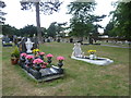
Strood Cemetery, Cuxton Road
This cemetery was opened in 1883 and is also known as Rochester, Strood Cemetery. It has good views across the Medway to Rochester. An interesting account of a visit can be seen at http://goffniksgruesomegraveyardguide.blogspot.co.uk/2013/05/strood-cemetery-cuxton-road.html
Image: © Marathon
Taken: 13 Aug 2013
0.12 miles