IMAGES TAKEN NEAR TO
Pine Road, ROCHESTER, ME2 2HX
Introduction
This page details the photographs taken nearby to Pine Road, ME2 2HX by members of the Geograph project.
The Geograph project started in 2005 with the aim of publishing, organising and preserving representative images for every square kilometre of Great Britain, Ireland and the Isle of Man.

There are currently over 7.5m images from over14,400 individuals and you can help contribute to the project by visiting https://www.geograph.org.uk
Image Map (Loading...)


Getting Data...Please wait
Leaflet Map data © OpenStreetMap
Images are licensed for reuse under creativecommons.org/licenses/by-sa/2.0
Notes
- Clicking on the map will re-center to the selected point.
- The higher the marker number, the further away the image location is from the centre of the postcode.
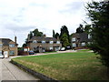
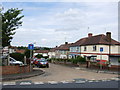
Image Listing (58 Images Found)
Images are licensed for reuse under creativecommons.org/licenses/by-sa/2.0
Image
Details
Distance
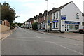
6
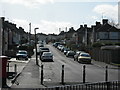
Cedar Road, Strood
Viewed from Darnley Road.
Image: © Danny P Robinson
Taken: 8 Mar 2009
0.07 miles
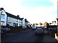
7
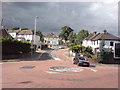
Mini Roundabout at Northcote Road, Strood
This is a busy junction between Darnley Road (to left), Northcote Road (ahead) and the A228 Cuxton Road (behind and to the right).
Image: © Danny P Robinson
Taken: 20 Jul 2008
0.07 miles