IMAGES TAKEN NEAR TO
Empire Road, ROCHESTER, ME2 2GA
Introduction
This page details the photographs taken nearby to Empire Road, ME2 2GA by members of the Geograph project.
The Geograph project started in 2005 with the aim of publishing, organising and preserving representative images for every square kilometre of Great Britain, Ireland and the Isle of Man.

There are currently over 7.5m images from over14,400 individuals and you can help contribute to the project by visiting https://www.geograph.org.uk
Image Map
Images are licensed for reuse under creativecommons.org/licenses/by-sa/2.0
Notes
- Clicking on the map will re-center to the selected point.
- The higher the marker number, the further away the image location is from the centre of the postcode.
Image Listing (43 Images Found)
Images are licensed for reuse under creativecommons.org/licenses/by-sa/2.0
Image
Details
Distance
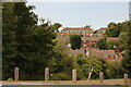
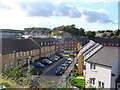
3
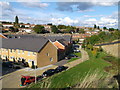
Medway Gate
New estate of houses, built within a former quarry.
Image: © David Anstiss
Taken: 14 Oct 2012
0.02 miles

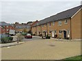
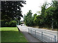
6
Horace Road, Medway Gate
New estate of houses, built within a former quarry.
Image: © David Anstiss
Taken: 14 Oct 2012
0.06 miles


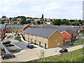
10
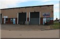
Ballard Business Park on Cuxton Road, Strood
Image: © David Howard
Taken: 28 Aug 2022
0.10 miles