IMAGES TAKEN NEAR TO
Whitehead Drive, ROCHESTER, ME2 2FY
Introduction
This page details the photographs taken nearby to Whitehead Drive, ME2 2FY by members of the Geograph project.
The Geograph project started in 2005 with the aim of publishing, organising and preserving representative images for every square kilometre of Great Britain, Ireland and the Isle of Man.

There are currently over 7.5m images from over14,400 individuals and you can help contribute to the project by visiting https://www.geograph.org.uk
Image Map
Images are licensed for reuse under creativecommons.org/licenses/by-sa/2.0
Notes
- Clicking on the map will re-center to the selected point.
- The higher the marker number, the further away the image location is from the centre of the postcode.
Image Listing (39 Images Found)
Images are licensed for reuse under creativecommons.org/licenses/by-sa/2.0
Image
Details
Distance
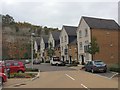
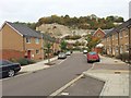
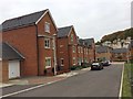
3
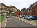
New housing in an old quarry
A footpath leads down from Cuxton Road (A228) along the edge of this old chalk quarry before bending around at 180 degrees to reach the new housing at the bottom.
Image: © Marathon
Taken: 18 Jan 2019
0.04 miles
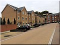
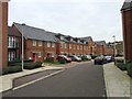
5
New housing in an old quarry
A footpath leads down from Cuxton Road (A228) along the edge of this old chalk quarry before bending around at 180 degrees to reach the new housing at the bottom.
Image: © Marathon
Taken: 18 Jan 2019
0.06 miles