IMAGES TAKEN NEAR TO
Priory Road, ROCHESTER, ME2 2EG
Introduction
This page details the photographs taken nearby to Priory Road, ME2 2EG by members of the Geograph project.
The Geograph project started in 2005 with the aim of publishing, organising and preserving representative images for every square kilometre of Great Britain, Ireland and the Isle of Man.

There are currently over 7.5m images from over14,400 individuals and you can help contribute to the project by visiting https://www.geograph.org.uk
Image Map
Images are licensed for reuse under creativecommons.org/licenses/by-sa/2.0
Notes
- Clicking on the map will re-center to the selected point.
- The higher the marker number, the further away the image location is from the centre of the postcode.
Image Listing (99 Images Found)
Images are licensed for reuse under creativecommons.org/licenses/by-sa/2.0
Image
Details
Distance
2

Derelict Factory, Priory Road, Strood (2)
Image: © Danny P Robinson
Taken: 2 Mar 2008
0.04 miles
3
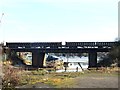
Railway Bridge over Temple Creek, Strood
Image: © Chris Whippet
Taken: 19 Jan 2014
0.08 miles
5

Samaritans, Priory Road, Strood
There will always be at least one volunteer on duty here -- you have to admire them.
Image: © Danny P Robinson
Taken: 2 Mar 2008
0.09 miles
6
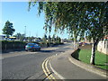
Smith Street, Strood
At the junction with Priory Road.
Image: © Danny P Robinson
Taken: 2 Mar 2008
0.09 miles
7
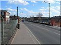
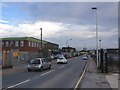
Priory Road, Strood
Looking towards Knight Road.
Image: © Danny P Robinson
Taken: 8 Mar 2009
0.09 miles

9
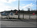
Demolition Site, Priory Road, Strood
There used to be factory here, see this photo Image
Image: © Danny P Robinson
Taken: 8 Mar 2009
0.10 miles
10
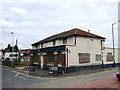
The Britannia, Strood
On the corner of Cuxton Road and Priory Road. The area is being redeveloped into flats.
Image: © Chris Whippet
Taken: 17 Jun 2009
0.11 miles