IMAGES TAKEN NEAR TO
Humber Crescent, ROCHESTER, ME2 2DX
Introduction
This page details the photographs taken nearby to Humber Crescent, ME2 2DX by members of the Geograph project.
The Geograph project started in 2005 with the aim of publishing, organising and preserving representative images for every square kilometre of Great Britain, Ireland and the Isle of Man.

There are currently over 7.5m images from over14,400 individuals and you can help contribute to the project by visiting https://www.geograph.org.uk
Image Map
Images are licensed for reuse under creativecommons.org/licenses/by-sa/2.0
Notes
- Clicking on the map will re-center to the selected point.
- The higher the marker number, the further away the image location is from the centre of the postcode.
Image Listing (48 Images Found)
Images are licensed for reuse under creativecommons.org/licenses/by-sa/2.0
Image
Details
Distance
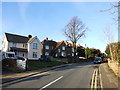
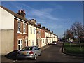
1
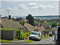
View east from Columbine Close
The road going down the hill is Daffodil Road.
Image: © Robin Webster
Taken: 13 Jun 2012
0.06 miles
2
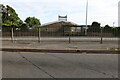
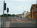
Strood Sports Centre on Watling Street
I began my journey on part of the A5 Watling Street in Hendon, which I have discovered crosses the Thames and becomes the A2 to Dover.
Image: © David Howard
Taken: 28 Aug 2022
0.11 miles
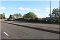
5
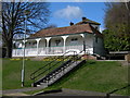
Pavilion Building, Darnley Road Recreation Ground
Image: © Danny P Robinson
Taken: 8 Mar 2009
0.12 miles
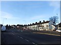
10
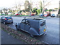
Old Citroen 2CV parked on Watling Street, Strood
Image: © Chris Whippet
Taken: 19 Jan 2014
0.14 miles