IMAGES TAKEN NEAR TO
Commercial Road, ROCHESTER, ME2 2AD
Introduction
This page details the photographs taken nearby to Commercial Road, ME2 2AD by members of the Geograph project.
The Geograph project started in 2005 with the aim of publishing, organising and preserving representative images for every square kilometre of Great Britain, Ireland and the Isle of Man.

There are currently over 7.5m images from over14,400 individuals and you can help contribute to the project by visiting https://www.geograph.org.uk
Image Map
Images are licensed for reuse under creativecommons.org/licenses/by-sa/2.0
Notes
- Clicking on the map will re-center to the selected point.
- The higher the marker number, the further away the image location is from the centre of the postcode.
Image Listing (169 Images Found)
Images are licensed for reuse under creativecommons.org/licenses/by-sa/2.0
Image
Details
Distance
1
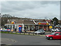
McDonald's, Commercial Road, Strood
One of several McDonald's outlets near here. This one is open 24 hours every day.
Image: © Danny P Robinson
Taken: 2 Mar 2008
0.04 miles
2
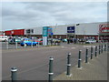
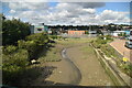
Janes' Creek & retail park, Strood
Several culverts drain into this creek which then runs about 300 metres SE before joining the River Medway at Bridge Reach. The small retail park (just 6 shops) is separated from the creek by the access road for the Civic Centre.
Old maps show the creek used to be joined by Pelican Creek at this point. Pelican Creek ran at right angles to Janes' Creek along the line of the shops now in view.
Image: © Penny Mayes
Taken: 27 Mar 2006
0.04 miles
3
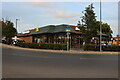
McDonald's on Commercial Road, Strood
The arrow is for a one way street not a roundabout.
Image: © David Howard
Taken: 28 Aug 2022
0.06 miles
7
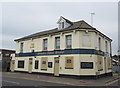
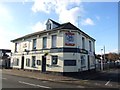
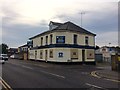
Formerly the Alma public house
This pub on the junction of Alma Place (on the right) and Knight Road has closed.
It was part of the Shepherd Neame brewery chain.
Image: © David Anstiss
Taken: 20 Jun 2015
0.07 miles
9
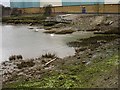
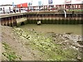
Muddy creek in Strood
Several culverts drain into this creek which runs down under the railway bridge to join the river Medway about 300 metres SE. The building in the background is Morrison's http://www.geograph.org.uk/photo/143966 See also Image
Image: © Penny Mayes
Taken: 27 Mar 2006
0.07 miles
10
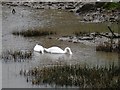
Swans in the creek
How do they stay so pristine white in this muddy creek? For wider views of the creek see other pics for this square Image
Image: © Penny Mayes
Taken: 27 Mar 2006
0.07 miles