IMAGES TAKEN NEAR TO
Strood Retail Park, Commercial Road, ROCHESTER, ME2 2AB
Introduction
This page details the photographs taken nearby to Strood Retail Park, Commercial Road, ME2 2AB by members of the Geograph project.
The Geograph project started in 2005 with the aim of publishing, organising and preserving representative images for every square kilometre of Great Britain, Ireland and the Isle of Man.

There are currently over 7.5m images from over14,400 individuals and you can help contribute to the project by visiting https://www.geograph.org.uk
Image Map
Images are licensed for reuse under creativecommons.org/licenses/by-sa/2.0
Notes
- Clicking on the map will re-center to the selected point.
- The higher the marker number, the further away the image location is from the centre of the postcode.
Image Listing (222 Images Found)
Images are licensed for reuse under creativecommons.org/licenses/by-sa/2.0
Image
Details
Distance
1
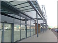
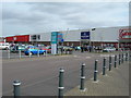
Footpath beside new retails units in Strood Retail Park
This was the former B&Q superstore, now being refurbished into 4 premises, M&S Food Hall, B+M Store, Maplins and The Gym (above B+M).
Image: © David Anstiss
Taken: 21 Jun 2017
0.02 miles
2
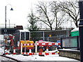
Christmas tree, Strood
The poor tree is surrounded by roadworks.
Image: © Chris Whippet
Taken: 21 Dec 2009
0.06 miles
3
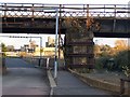
Railway Bridge over Esplanade Road, Strood
Rochester Castle and Cathedral in background,across River Medway.
Road leads to Civic Centre carpark and new Health Centre.
Railway goes right to Maidstone, via the picturesque Medway Valley.
Also goes left towards Strood/Gillingham.
Image: © David Anstiss
Taken: 12 Nov 2008
0.06 miles
5
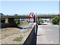
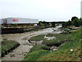
Janes' Creek & retail park, Strood
Several culverts drain into this creek which then runs about 300 metres SE before joining the River Medway at Bridge Reach. The small retail park (just 6 shops) is separated from the creek by the access road for the Civic Centre.
Old maps show the creek used to be joined by Pelican Creek at this point. Pelican Creek ran at right angles to Janes' Creek along the line of the shops now in view.
Image: © Penny Mayes
Taken: 27 Mar 2006
0.07 miles
6
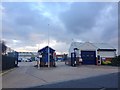
Medway Works Depot and Strood Ambulance Station
Image: © Chris Whippet
Taken: 5 Nov 2014
0.07 miles

10
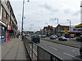
High Street, Strood (1)
Looking towards Rochester Bridge. This is the A2, a major artery through the Medway Towns. A road will have existed here since Roman times.
Image: © Danny P Robinson
Taken: 2 Mar 2008
0.08 miles