IMAGES TAKEN NEAR TO
Herying Close, ROCHESTER, ME2 1NE
Introduction
This page details the photographs taken nearby to Herying Close, ME2 1NE by members of the Geograph project.
The Geograph project started in 2005 with the aim of publishing, organising and preserving representative images for every square kilometre of Great Britain, Ireland and the Isle of Man.

There are currently over 7.5m images from over14,400 individuals and you can help contribute to the project by visiting https://www.geograph.org.uk
Image Map
Images are licensed for reuse under creativecommons.org/licenses/by-sa/2.0
Notes
- Clicking on the map will re-center to the selected point.
- The higher the marker number, the further away the image location is from the centre of the postcode.
Image Listing (70 Images Found)
Images are licensed for reuse under creativecommons.org/licenses/by-sa/2.0
Image
Details
Distance
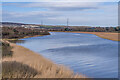
4
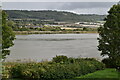
River Medway at Halling
This view of the River Medway looks upriver from near the Bishop's Palace and church. The chalk quarries between Wouldham and Burham can be seen in the distance on the other side of the river. Beyond are the woods of Wouldham Common on the slopes of the North Downs.
Image: © Marathon
Taken: 18 Aug 2013
0.13 miles
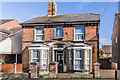
5
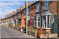
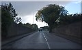
High Street
Turn of the 19th/20th Centuries terraced housing on High Street.
Image: © Ian Capper
Taken: 17 Feb 2022
0.14 miles
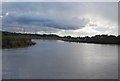
6
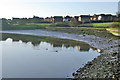
River Medway at Halling
Looking upstream, although it is tidal here.
Image: © Robin Webster
Taken: 3 Feb 2007
0.14 miles
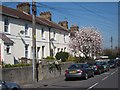
8
Upnor Lodge
Victorian house on High Street.
Image: © Ian Capper
Taken: 17 Feb 2022
0.15 miles
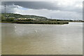
10
River Medway
Looking downstream along the River Medway from Peters Bridge.
Image: © Ian Capper
Taken: 17 Feb 2022
0.16 miles