IMAGES TAKEN NEAR TO
Sundridge Hill, ROCHESTER, ME2 1LF
Introduction
This page details the photographs taken nearby to Sundridge Hill, ME2 1LF by members of the Geograph project.
The Geograph project started in 2005 with the aim of publishing, organising and preserving representative images for every square kilometre of Great Britain, Ireland and the Isle of Man.

There are currently over 7.5m images from over14,400 individuals and you can help contribute to the project by visiting https://www.geograph.org.uk
Image Map
Images are licensed for reuse under creativecommons.org/licenses/by-sa/2.0
Notes
- Clicking on the map will re-center to the selected point.
- The higher the marker number, the further away the image location is from the centre of the postcode.
Image Listing (22 Images Found)
Images are licensed for reuse under creativecommons.org/licenses/by-sa/2.0
Image
Details
Distance
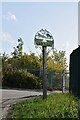
7
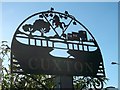
Cuxton Village Sign (close-up)
Image: © David Anstiss
Taken: 14 Oct 2012
0.12 miles
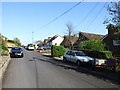
8
Cuxton Village Sign
Beside Rochester Road, leading down to village (from the M2 motorway) beside the River Medway.
Image: © David Anstiss
Taken: 14 Oct 2012
0.12 miles
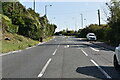
9
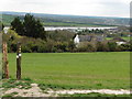
The North Downs Way near Longhoes Wood
Looking South towards Cuxton and the River Medway.
Image: © Dave Kelly
Taken: 18 Apr 2016
0.13 miles
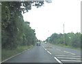
10
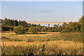
Farmland, Cuxton, Kent
Looking across farmland towards the bridges which carry the motorway and the Eurostar trains.
Image: © Christine Matthews
Taken: 21 Aug 2011
0.14 miles