IMAGES TAKEN NEAR TO
Germander Avenue, ROCHESTER, ME2 1FR
Introduction
This page details the photographs taken nearby to Germander Avenue, ME2 1FR by members of the Geograph project.
The Geograph project started in 2005 with the aim of publishing, organising and preserving representative images for every square kilometre of Great Britain, Ireland and the Isle of Man.

There are currently over 7.5m images from over14,400 individuals and you can help contribute to the project by visiting https://www.geograph.org.uk
Image Map
Images are licensed for reuse under creativecommons.org/licenses/by-sa/2.0
Notes
- Clicking on the map will re-center to the selected point.
- The higher the marker number, the further away the image location is from the centre of the postcode.
Image Listing (33 Images Found)
Images are licensed for reuse under creativecommons.org/licenses/by-sa/2.0
Image
Details
Distance
4
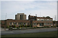
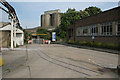
Former Rochester Cement Works offices
The main part of the cement works was behind the photographer, but has now been demolished. The part of the works on the east side of the main road with the offices and storage silos still exists.
Image: © Alan Murray-Rust
Taken: 1 May 2011
0.12 miles
5

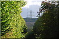
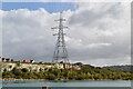
Footbridge in Quarry
On RS201 footpath from A228 Halling By-pass to Pilgrims Road. Cement works on right and quarry on left.
Image: © David Anstiss
Taken: 12 Dec 2008
0.13 miles
9
Rochester Cement Works
The entrance into the eastern part of the site, now closed. Note the rails of the internal narrow gauge railway system in the foreground. The building to the right appears to have been a canteen.
Image: © Alan Murray-Rust
Taken: 1 May 2011
0.15 miles
10
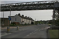
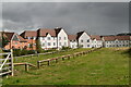
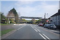
Formby Terrace
This row of houses was built for workers at the neighbouring quarry and cement works, to which the conveyor bridge belonged.
Image: © Alan Murray-Rust
Taken: 1 May 2011
0.16 miles