IMAGES TAKEN NEAR TO
Britannia Close, ROCHESTER, ME2 1DG
Introduction
This page details the photographs taken nearby to Britannia Close, ME2 1DG by members of the Geograph project.
The Geograph project started in 2005 with the aim of publishing, organising and preserving representative images for every square kilometre of Great Britain, Ireland and the Isle of Man.

There are currently over 7.5m images from over14,400 individuals and you can help contribute to the project by visiting https://www.geograph.org.uk
Image Map
Images are licensed for reuse under creativecommons.org/licenses/by-sa/2.0
Notes
- Clicking on the map will re-center to the selected point.
- The higher the marker number, the further away the image location is from the centre of the postcode.
Image Listing (90 Images Found)
Images are licensed for reuse under creativecommons.org/licenses/by-sa/2.0
Image
Details
Distance
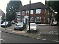
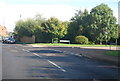
3
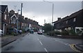
Upnor Lodge
Victorian house on High Street.
Image: © Ian Capper
Taken: 17 Feb 2022
0.05 miles
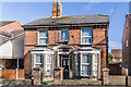
5
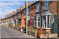
High Street
Turn of the 19th/20th Centuries terraced housing on High Street.
Image: © Ian Capper
Taken: 17 Feb 2022
0.05 miles
7
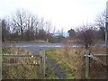
Footpath across A228 Halling By-pass
From Meadow Crescent, Upper Halling, crosses to Sylvestre Close on High Street, Halling.
Image: © David Anstiss
Taken: 12 Dec 2008
0.09 miles
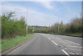
10
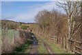
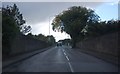
Footpath alongside the A228
Footpath alongside the A228 Halling bypass, separated by the hedge on the right.
Image: © Ian Capper
Taken: 17 Feb 2022
0.10 miles