IMAGES TAKEN NEAR TO
Vicarage Close, ROCHESTER, ME2 1BH
Introduction
This page details the photographs taken nearby to Vicarage Close, ME2 1BH by members of the Geograph project.
The Geograph project started in 2005 with the aim of publishing, organising and preserving representative images for every square kilometre of Great Britain, Ireland and the Isle of Man.

There are currently over 7.5m images from over14,400 individuals and you can help contribute to the project by visiting https://www.geograph.org.uk
Image Map
Images are licensed for reuse under creativecommons.org/licenses/by-sa/2.0
Notes
- Clicking on the map will re-center to the selected point.
- The higher the marker number, the further away the image location is from the centre of the postcode.
Image Listing (89 Images Found)
Images are licensed for reuse under creativecommons.org/licenses/by-sa/2.0
Image
Details
Distance
2
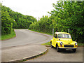
Yellow Morris Minor on Vicarage Road
A bright yellow four door Morris Minor 1000, built in 1962.
Image: © Oast House Archive
Taken: 21 May 2009
0.06 miles
3
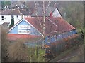
Halling Baptist Chapel
On Vicarage Road. Seen from footbridge.
It is a corrugated sheet shed, but nicely painted.
Image: © David Anstiss
Taken: 12 Dec 2008
0.06 miles
7
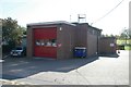
Halling fire station
Halling fire station, Vicarage Road, Halling, Kent
Image: © Kevin Hale
Taken: 17 Oct 2007
0.08 miles
10
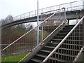
Footbridge over A228 Halling By-Pass
Leads from Vicarage Road to High Street, Halling.
By-pass heading right leads to Snodland/M20, or left to Cuxton/M2.
Image: © David Anstiss
Taken: 12 Dec 2008
0.09 miles