IMAGES TAKEN NEAR TO
Woodlands Road, AYLESFORD, ME20 7QF
Introduction
This page details the photographs taken nearby to Woodlands Road, ME20 7QF by members of the Geograph project.
The Geograph project started in 2005 with the aim of publishing, organising and preserving representative images for every square kilometre of Great Britain, Ireland and the Isle of Man.

There are currently over 7.5m images from over14,400 individuals and you can help contribute to the project by visiting https://www.geograph.org.uk
Image Map
Images are licensed for reuse under creativecommons.org/licenses/by-sa/2.0
Notes
- Clicking on the map will re-center to the selected point.
- The higher the marker number, the further away the image location is from the centre of the postcode.
Image Listing (11 Images Found)
Images are licensed for reuse under creativecommons.org/licenses/by-sa/2.0
Image
Details
Distance

3
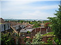
Ditton Gardens
Rear gardens on Holt Hill, Ditton. Aylesford Newsprint in the distance.
Image: © Danny Nicholson
Taken: 4 Jun 2006
0.12 miles
5

Austins at Primrose Drive
An Austin A35 to left and A30 to right.
Image: © Oast House Archive
Taken: 7 Sep 2009
0.18 miles