IMAGES TAKEN NEAR TO
London Road, AYLESFORD, ME20 7QA
Introduction
This page details the photographs taken nearby to London Road, ME20 7QA by members of the Geograph project.
The Geograph project started in 2005 with the aim of publishing, organising and preserving representative images for every square kilometre of Great Britain, Ireland and the Isle of Man.

There are currently over 7.5m images from over14,400 individuals and you can help contribute to the project by visiting https://www.geograph.org.uk
Image Map
Images are licensed for reuse under creativecommons.org/licenses/by-sa/2.0
Notes
- Clicking on the map will re-center to the selected point.
- The higher the marker number, the further away the image location is from the centre of the postcode.
Image Listing (13 Images Found)
Images are licensed for reuse under creativecommons.org/licenses/by-sa/2.0
Image
Details
Distance


9
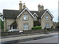
Houses on Hall Road
These houses are opposite the entrance to the Royal British Legion Village.
Image: © Marathon
Taken: 8 Aug 2014
0.19 miles
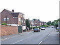
10
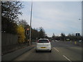
London Road at the junction of Hall Road, Ditton
Image: © David Howard
Taken: 21 Apr 2013
0.20 miles