IMAGES TAKEN NEAR TO
Hermitage Lane, AYLESFORD, ME20 7PT
Introduction
This page details the photographs taken nearby to Hermitage Lane, ME20 7PT by members of the Geograph project.
The Geograph project started in 2005 with the aim of publishing, organising and preserving representative images for every square kilometre of Great Britain, Ireland and the Isle of Man.

There are currently over 7.5m images from over14,400 individuals and you can help contribute to the project by visiting https://www.geograph.org.uk
Image Map
Images are licensed for reuse under creativecommons.org/licenses/by-sa/2.0
Notes
- Clicking on the map will re-center to the selected point.
- The higher the marker number, the further away the image location is from the centre of the postcode.
Image Listing (15 Images Found)
Images are licensed for reuse under creativecommons.org/licenses/by-sa/2.0
Image
Details
Distance

5
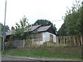
Aylesford: Former servicemen's chalets on Hermitage Lane
There were originally about 30 of these chalets erected by the British Legion on Hermitage Lane to house recuperating servicemen, but almost all of them are now in a derelict state, some even burnt out, with the site surrounded by Heras fencing.
Image: © Nigel Cox
Taken: 25 Jun 2015
0.17 miles
7
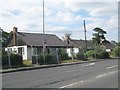
Boarded up bungalow, Royal British Legion Village
A "Preston Hall" bungalow, located on Hermitage Lane and originally built for ex-servicemen.
Image: © Chris Whippet
Taken: 23 Sep 2010
0.19 miles
9
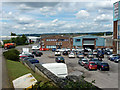
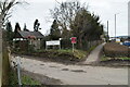
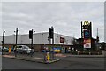
Quarry Wood industrial estate
A small part of this large and busy estate.
Image: © Robin Webster
Taken: 12 Jul 2012
0.20 miles