IMAGES TAKEN NEAR TO
East Park Road, AYLESFORD, ME20 7NP
Introduction
This page details the photographs taken nearby to East Park Road, ME20 7NP by members of the Geograph project.
The Geograph project started in 2005 with the aim of publishing, organising and preserving representative images for every square kilometre of Great Britain, Ireland and the Isle of Man.

There are currently over 7.5m images from over14,400 individuals and you can help contribute to the project by visiting https://www.geograph.org.uk
Image Map
Images are licensed for reuse under creativecommons.org/licenses/by-sa/2.0
Notes
- Clicking on the map will re-center to the selected point.
- The higher the marker number, the further away the image location is from the centre of the postcode.
Image Listing (30 Images Found)
Images are licensed for reuse under creativecommons.org/licenses/by-sa/2.0
Image
Details
Distance
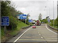
1
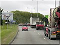
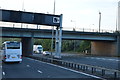
Coldharbour Lane (A20 Link Road), Maidstone
The link road to the A20 from Junction 5 of the M20.
Image: © David Dixon
Taken: 14 May 2013
0.10 miles
4
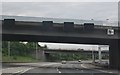
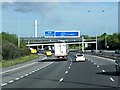
Motorway Signs on M20
At junction 5.
Image: © Oast House Archive
Taken: 15 Apr 2009
0.14 miles

8
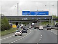
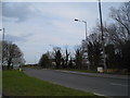
The A20 approaching the roundabout for the M20 junction 5
Image: © David Howard
Taken: 21 Apr 2013
0.17 miles
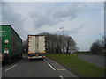
10
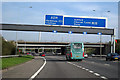
M20, Sliproad to the A20 at Junction 5
Image: © David Dixon
Taken: 14 May 2013
0.18 miles