IMAGES TAKEN NEAR TO
Bridge Place, AYLESFORD, ME20 7JJ
Introduction
This page details the photographs taken nearby to Bridge Place, ME20 7JJ by members of the Geograph project.
The Geograph project started in 2005 with the aim of publishing, organising and preserving representative images for every square kilometre of Great Britain, Ireland and the Isle of Man.

There are currently over 7.5m images from over14,400 individuals and you can help contribute to the project by visiting https://www.geograph.org.uk
Image Map
Images are licensed for reuse under creativecommons.org/licenses/by-sa/2.0
Notes
- Clicking on the map will re-center to the selected point.
- The higher the marker number, the further away the image location is from the centre of the postcode.
Image Listing (265 Images Found)
Images are licensed for reuse under creativecommons.org/licenses/by-sa/2.0
Image
Details
Distance
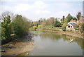
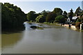
2
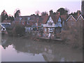
River Medway looking westwards from Aylesford old bridge
Image: © pam fray
Taken: 27 Mar 2008
0.02 miles
3
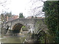
The old bridge, Aylesford, viewed from the footpath
Traffic roars nearby over the modern bridge, leaving this lovely one to relative peace and quiet.
Image: © pam fray
Taken: 27 Mar 2008
0.02 miles
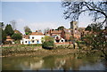
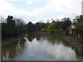
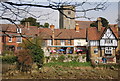
9
The Chequers, Aylesford
A riverside public house, viewed from the old bridge Image
Image: © Stephen Craven
Taken: 5 Mar 2010
0.04 miles
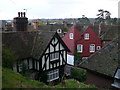
10
The Chequers, Aylesford
A fine riverside pub serving good food and beer.
Image: © N Chadwick
Taken: 15 Apr 2010
0.04 miles