IMAGES TAKEN NEAR TO
Bull Lane, AYLESFORD, ME20 7HT
Introduction
This page details the photographs taken nearby to Bull Lane, ME20 7HT by members of the Geograph project.
The Geograph project started in 2005 with the aim of publishing, organising and preserving representative images for every square kilometre of Great Britain, Ireland and the Isle of Man.

There are currently over 7.5m images from over14,400 individuals and you can help contribute to the project by visiting https://www.geograph.org.uk
Image Map
Images are licensed for reuse under creativecommons.org/licenses/by-sa/2.0
Notes
- Clicking on the map will re-center to the selected point.
- The higher the marker number, the further away the image location is from the centre of the postcode.
Image Listing (34 Images Found)
Images are licensed for reuse under creativecommons.org/licenses/by-sa/2.0
Image
Details
Distance
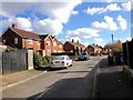
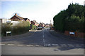
1
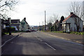
Bull Lane, Eccles
The main road in the village. Named after the Red Bull, on the left.
Image: © Robin Webster
Taken: 4 Feb 2007
0.02 miles
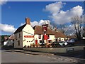
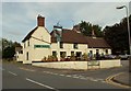
3
Red Bull Pub, Eccles
On junction of Bull Lane and Maclenders Lane.
Image: © David Anstiss
Taken: 21 Dec 2008
0.03 miles

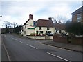
9
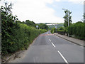
Bull Lane
Leading out of Eccles towards Pilgrims Way junction 1/2 km ahead.
Image: © Oast House Archive
Taken: 21 Jun 2010
0.08 miles
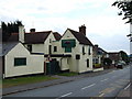
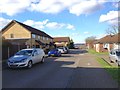
10
Greenfield Close, Eccles
The first houses in Eccles when entering from the north.
Image: © Robin Webster
Taken: 4 Feb 2007
0.08 miles