IMAGES TAKEN NEAR TO
Eccles Row, AYLESFORD, ME20 7HS
Introduction
This page details the photographs taken nearby to Eccles Row, ME20 7HS by members of the Geograph project.
The Geograph project started in 2005 with the aim of publishing, organising and preserving representative images for every square kilometre of Great Britain, Ireland and the Isle of Man.

There are currently over 7.5m images from over14,400 individuals and you can help contribute to the project by visiting https://www.geograph.org.uk
Image Map
Images are licensed for reuse under creativecommons.org/licenses/by-sa/2.0
Notes
- Clicking on the map will re-center to the selected point.
- The higher the marker number, the further away the image location is from the centre of the postcode.
Image Listing (45 Images Found)
Images are licensed for reuse under creativecommons.org/licenses/by-sa/2.0
Image
Details
Distance
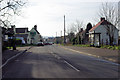
2
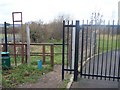
Footpath on Eccles Row
Path (MR454) leads to Eccles Lake/Reservoir and Medway Valley Walk, Wouldham to Aylesford section. Big black gate on right, is entrance to St Mark's Church of England Primary School.
Image: © David Anstiss
Taken: 21 Dec 2008
0.07 miles

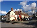
7
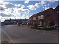
Bull Lane, Eccles
The main road in the village. Named after the Red Bull, on the left.
Image: © Robin Webster
Taken: 4 Feb 2007
0.09 miles
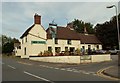
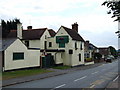
8
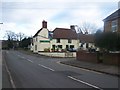
Red Bull Pub, Eccles
On junction of Bull Lane and Maclenders Lane.
Image: © David Anstiss
Taken: 21 Dec 2008
0.10 miles