IMAGES TAKEN NEAR TO
Rochester Road, AYLESFORD, ME20 7ED
Introduction
This page details the photographs taken nearby to Rochester Road, ME20 7ED by members of the Geograph project.
The Geograph project started in 2005 with the aim of publishing, organising and preserving representative images for every square kilometre of Great Britain, Ireland and the Isle of Man.

There are currently over 7.5m images from over14,400 individuals and you can help contribute to the project by visiting https://www.geograph.org.uk
Image Map
Images are licensed for reuse under creativecommons.org/licenses/by-sa/2.0
Notes
- Clicking on the map will re-center to the selected point.
- The higher the marker number, the further away the image location is from the centre of the postcode.
Image Listing (5 Images Found)
Images are licensed for reuse under creativecommons.org/licenses/by-sa/2.0
Image
Details
Distance
2
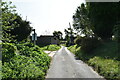
Footpath on Rochester Road
Near Cowleaze Farm. Path leads to Little Cossington Farm on Pratling Street. Frost tinged North Downs seen in background.
Image: © David Anstiss
Taken: 4 Jan 2009
0.18 miles
3
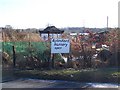
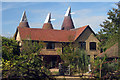
Aylesford Nursery on Rochester Road
This nursery used to be Rosie's Nursery - specialising in Hardy Geraniums. Was always in the back pages of the Amateur Gardening Magazine 2003-2008. Now a general Plant and Bulb nursery.
Image: © David Anstiss
Taken: 4 Jan 2009
0.20 miles
4
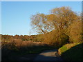
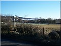
Pratling Street
This is Pratling Street just north of Little Cossington Farm. This had been a glorious autumn day and it was now about half an hour before sunset.
Image: © Marathon
Taken: 10 Nov 2013
0.23 miles