IMAGES TAKEN NEAR TO
Hall Road, AYLESFORD, ME20 7DS
Introduction
This page details the photographs taken nearby to Hall Road, ME20 7DS by members of the Geograph project.
The Geograph project started in 2005 with the aim of publishing, organising and preserving representative images for every square kilometre of Great Britain, Ireland and the Isle of Man.

There are currently over 7.5m images from over14,400 individuals and you can help contribute to the project by visiting https://www.geograph.org.uk
Image Map
Images are licensed for reuse under creativecommons.org/licenses/by-sa/2.0
Notes
- Clicking on the map will re-center to the selected point.
- The higher the marker number, the further away the image location is from the centre of the postcode.
Image Listing (65 Images Found)
Images are licensed for reuse under creativecommons.org/licenses/by-sa/2.0
Image
Details
Distance
4
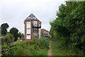
Medway Court
A new development by the River Medway
Image: © N Chadwick
Taken: 11 Sep 2010
0.13 miles
5
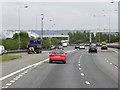
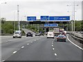
Northbound M20, Entry Sliproad at Junction 5
Image: © David Dixon
Taken: 17 May 2013
0.13 miles
9
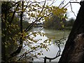
River Medway near Little Preston
Looking west towards Aylesford.
Image: © Penny Mayes
Taken: 5 Dec 2005
0.15 miles
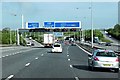
10

Slip road to A20 leaving M20 at Junction 5
Image: © Colin Pyle
Taken: 13 May 2013
0.15 miles