IMAGES TAKEN NEAR TO
High Street, AYLESFORD, ME20 7DA
Introduction
This page details the photographs taken nearby to High Street, ME20 7DA by members of the Geograph project.
The Geograph project started in 2005 with the aim of publishing, organising and preserving representative images for every square kilometre of Great Britain, Ireland and the Isle of Man.

There are currently over 7.5m images from over14,400 individuals and you can help contribute to the project by visiting https://www.geograph.org.uk
Image Map
Images are licensed for reuse under creativecommons.org/licenses/by-sa/2.0
Notes
- Clicking on the map will re-center to the selected point.
- The higher the marker number, the further away the image location is from the centre of the postcode.
Image Listing (30 Images Found)
Images are licensed for reuse under creativecommons.org/licenses/by-sa/2.0
Image
Details
Distance
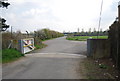
1
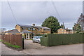
Corporation Cottages
Housing adjacent to Aylesford Wastewater Treatment Plant.
Image: © Ian Capper
Taken: 17 Feb 2022
0.01 miles
2
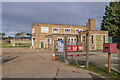
Aylesford Wastewater Treatment Plant
Office Buildings at a sewage works west of Aylesford.
Image: © Ian Capper
Taken: 17 Feb 2022
0.03 miles
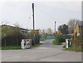
4
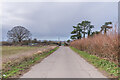
Access road
Access road to Aylesford Wastewater Treatment Plant.
Image: © Ian Capper
Taken: 17 Feb 2022
0.04 miles
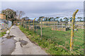
5
Flood gate, Aylesford water treatment works
Image: © N Chadwick
Taken: 15 Apr 2010
0.05 miles
6
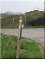
A jauntily angled waymark, The Medway Valley Walk
Image: © N Chadwick
Taken: 15 Apr 2010
0.07 miles
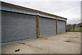
8
Aylesford Wastewater Treatment Plant
Sewage works west of Aylesford.
Image: © Ian Capper
Taken: 17 Feb 2022
0.07 miles
10
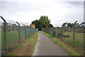
Medway Valley Walk through Sewage Works
Image: © N Chadwick
Taken: 30 Aug 2011
0.08 miles