IMAGES TAKEN NEAR TO
Johnson Walk, ME20 6UU
Introduction
This page details the photographs taken nearby to Johnson Walk, ME20 6UU by members of the Geograph project.
The Geograph project started in 2005 with the aim of publishing, organising and preserving representative images for every square kilometre of Great Britain, Ireland and the Isle of Man.

There are currently over 7.5m images from over14,400 individuals and you can help contribute to the project by visiting https://www.geograph.org.uk
Image Map
Images are licensed for reuse under creativecommons.org/licenses/by-sa/2.0
Notes
- Clicking on the map will re-center to the selected point.
- The higher the marker number, the further away the image location is from the centre of the postcode.
Image Listing (39 Images Found)
Images are licensed for reuse under creativecommons.org/licenses/by-sa/2.0
Image
Details
Distance
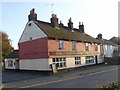
4

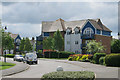
The Bricklayers Arms, New Hythe
The colour scheme has changed since earlier views - e.g. Image It is probably no accident that the new colour is a fair match for that of the boarded houses in the large new housing development nearby. And that colour no doubt was no accident, being selected to sell. So the pub has made a good choice.
Image: © Robin Webster
Taken: 12 Jul 2012
0.08 miles
5
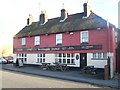
The Bricklayers Arms, New Hythe
On New Hythe Lane.
Image: © David Anstiss
Taken: 21 Dec 2008
0.09 miles