IMAGES TAKEN NEAR TO
Southey Way, AYLESFORD, ME20 6TS
Introduction
This page details the photographs taken nearby to Southey Way, ME20 6TS by members of the Geograph project.
The Geograph project started in 2005 with the aim of publishing, organising and preserving representative images for every square kilometre of Great Britain, Ireland and the Isle of Man.

There are currently over 7.5m images from over14,400 individuals and you can help contribute to the project by visiting https://www.geograph.org.uk
Image Map (Loading...)


Getting Data...Please wait
Leaflet Map data © OpenStreetMap
Images are licensed for reuse under creativecommons.org/licenses/by-sa/2.0
Notes
- Clicking on the map will re-center to the selected point.
- The higher the marker number, the further away the image location is from the centre of the postcode.
Image Listing (104 Images Found)
Images are licensed for reuse under creativecommons.org/licenses/by-sa/2.0
Image
Details
Distance
5
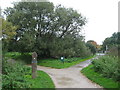
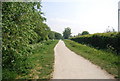
Footpath junction on Leybourne Lakes near Gighill Road
A circular walk around the lake in the Country Park leads left. Another path leads right towards the Leybourne Way opposite Gighill Road.
Image: © David Anstiss
Taken: 5 Oct 2010
0.07 miles
6
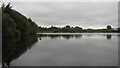
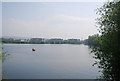
Leybourne Lake
As seen from a circular path leading around the lake in the country park.
Image: © David Anstiss
Taken: 5 Oct 2010
0.09 miles
8
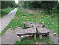
Butterfly Bench in Leybourne Lake
This millennium bench is beside a circular walk around the lake in the country park. The lake is unseen on the left.
Image: © David Anstiss
Taken: 5 Oct 2010
0.10 miles
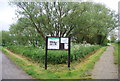
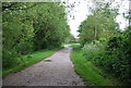
10
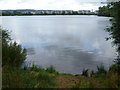
Leybourne Lakes Country Park
Leybourne Lakes Country Park has been developed from former gravel workings. It was opened by the Mayor of Tonbridge and Malling on 11th September 2004. This view looks across to 'The Lakes' housing development.
Image: © Marathon
Taken: 18 Aug 2013
0.11 miles