IMAGES TAKEN NEAR TO
Thackeray Road, AYLESFORD, ME20 6TJ
Introduction
This page details the photographs taken nearby to Thackeray Road, ME20 6TJ by members of the Geograph project.
The Geograph project started in 2005 with the aim of publishing, organising and preserving representative images for every square kilometre of Great Britain, Ireland and the Isle of Man.

There are currently over 7.5m images from over14,400 individuals and you can help contribute to the project by visiting https://www.geograph.org.uk
Image Map
Images are licensed for reuse under creativecommons.org/licenses/by-sa/2.0
Notes
- Clicking on the map will re-center to the selected point.
- The higher the marker number, the further away the image location is from the centre of the postcode.
Image Listing (38 Images Found)
Images are licensed for reuse under creativecommons.org/licenses/by-sa/2.0
Image
Details
Distance
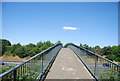
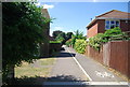
3
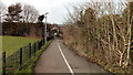
Footpath and cycleway to Chaucer Way
This path leads from New Hythe Lane, past several playing fields, towards a residential housing estate.
Image: © David Anstiss
Taken: 30 Dec 2017
0.07 miles
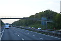
10
Footpath and cycle lane to Fielding Drive
Image: © N Chadwick
Taken: 10 Jul 2010
0.10 miles