IMAGES TAKEN NEAR TO
Scott Close, AYLESFORD, ME20 6QR
Introduction
This page details the photographs taken nearby to Scott Close, ME20 6QR by members of the Geograph project.
The Geograph project started in 2005 with the aim of publishing, organising and preserving representative images for every square kilometre of Great Britain, Ireland and the Isle of Man.

There are currently over 7.5m images from over14,400 individuals and you can help contribute to the project by visiting https://www.geograph.org.uk
Image Map
Images are licensed for reuse under creativecommons.org/licenses/by-sa/2.0
Notes
- Clicking on the map will re-center to the selected point.
- The higher the marker number, the further away the image location is from the centre of the postcode.
Image Listing (41 Images Found)
Images are licensed for reuse under creativecommons.org/licenses/by-sa/2.0
Image
Details
Distance
1
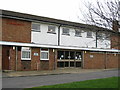
Ditton Community Centre
The large and multi-purpose Community Centre building at Ditton. For more information about Ditton parish please visit...http://www.dittonparishcouncil.gov.uk
Image: © Clive Stanley
Taken: 17 Feb 2005
0.02 miles
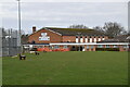


7

Ditton Church of England Junior School
The school is immediately to the south of the old schoolroom, now a heritage centre Image
Image: © Stephen Craven
Taken: 22 Mar 2009
0.10 miles
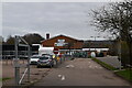
8
Houses on Cherry Orchard, Ditton
Situated on the edge of the housing estate, just off Kiln Barn Road.
Image: © Oast House Archive
Taken: 7 Sep 2009
0.11 miles