IMAGES TAKEN NEAR TO
St. Peters Road, AYLESFORD, ME20 6PH
Introduction
This page details the photographs taken nearby to St. Peters Road, ME20 6PH by members of the Geograph project.
The Geograph project started in 2005 with the aim of publishing, organising and preserving representative images for every square kilometre of Great Britain, Ireland and the Isle of Man.

There are currently over 7.5m images from over14,400 individuals and you can help contribute to the project by visiting https://www.geograph.org.uk
Image Map
Images are licensed for reuse under creativecommons.org/licenses/by-sa/2.0
Notes
- Clicking on the map will re-center to the selected point.
- The higher the marker number, the further away the image location is from the centre of the postcode.
Image Listing (40 Images Found)
Images are licensed for reuse under creativecommons.org/licenses/by-sa/2.0
Image
Details
Distance
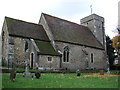
1
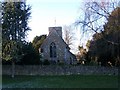
Ditton Parish Church of St Peter-AD-Vincula
On junction of New Road and St Peters Court Road.
Image: © David Anstiss
Taken: 4 Jan 2009
0.01 miles
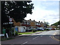

5

No flood round the bend
A sign for a flood, but there was no sign of a flood.
Image: © Robin Webster
Taken: 12 Jul 2012
0.05 miles
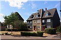

10

Ditton Church of England Junior School
The school is immediately to the south of the old schoolroom, now a heritage centre Image
Image: © Stephen Craven
Taken: 22 Mar 2009
0.08 miles