IMAGES TAKEN NEAR TO
Ditton, AYLESFORD, ME20 6PE
Introduction
This page details the photographs taken nearby to ME20 6PE by members of the Geograph project.
The Geograph project started in 2005 with the aim of publishing, organising and preserving representative images for every square kilometre of Great Britain, Ireland and the Isle of Man.

There are currently over 7.5m images from over14,400 individuals and you can help contribute to the project by visiting https://www.geograph.org.uk
Image Map
Images are licensed for reuse under creativecommons.org/licenses/by-sa/2.0
Notes
- Clicking on the map will re-center to the selected point.
- The higher the marker number, the further away the image location is from the centre of the postcode.
Image Listing (29 Images Found)
Images are licensed for reuse under creativecommons.org/licenses/by-sa/2.0
Image
Details
Distance
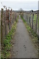
1
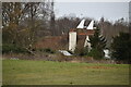
Park Farm
Within Bradbourne estate. Used as offices of Pinnacle - small computing firm.
Image: © David Anstiss
Taken: 27 Jan 2009
0.03 miles
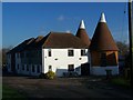
2
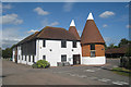
Oast House at Park Farm, Ditton, Kent
Image: © Oast House Archive
Taken: 7 Sep 2009
0.04 miles

5
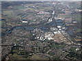
Ditton from the air
The River Medway and Leybourne Lakes are prominent.
Image: © Thomas Nugent
Taken: 28 Jan 2022
0.04 miles

7
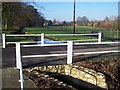
Road bridge and stream leading to Bradbourne House
Road is a private drive to Bradbourne Nursery, Walnut Row (small row of houses) and Park Farm (small business offices). Road heading right leads to Bradbourne Lane.
Image: © David Anstiss
Taken: 27 Jan 2009
0.07 miles