IMAGES TAKEN NEAR TO
Oak Drive, AYLESFORD, ME20 6NN
Introduction
This page details the photographs taken nearby to Oak Drive, ME20 6NN by members of the Geograph project.
The Geograph project started in 2005 with the aim of publishing, organising and preserving representative images for every square kilometre of Great Britain, Ireland and the Isle of Man.

There are currently over 7.5m images from over14,400 individuals and you can help contribute to the project by visiting https://www.geograph.org.uk
Image Map
Images are licensed for reuse under creativecommons.org/licenses/by-sa/2.0
Notes
- Clicking on the map will re-center to the selected point.
- The higher the marker number, the further away the image location is from the centre of the postcode.
Image Listing (20 Images Found)
Images are licensed for reuse under creativecommons.org/licenses/by-sa/2.0
Image
Details
Distance
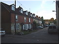
5

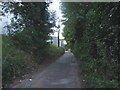
Terraced houses, Lower Bell Lane
A one-sided unmade close, with only these houses. The larger corner house has been converted from an off-licence.
Image: © Robin Webster
Taken: 12 Jul 2012
0.10 miles
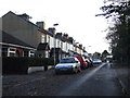
7
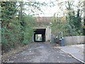
Bell Lane, Ditton
Bell Lane runs under the M20 towards the paper mills at New Hythe.
Image: © Chris Whippet
Taken: 17 Nov 2009
0.11 miles
10
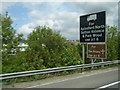
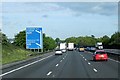
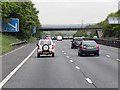
Information signs approaching Junction 6 on the M20
Image: © Colin Pyle
Taken: 13 May 2013
0.15 miles