IMAGES TAKEN NEAR TO
Oriole Way, AYLESFORD, ME20 6LW
Introduction
This page details the photographs taken nearby to Oriole Way, ME20 6LW by members of the Geograph project.
The Geograph project started in 2005 with the aim of publishing, organising and preserving representative images for every square kilometre of Great Britain, Ireland and the Isle of Man.

There are currently over 7.5m images from over14,400 individuals and you can help contribute to the project by visiting https://www.geograph.org.uk
Image Map
Images are licensed for reuse under creativecommons.org/licenses/by-sa/2.0
Notes
- Clicking on the map will re-center to the selected point.
- The higher the marker number, the further away the image location is from the centre of the postcode.
Image Listing (36 Images Found)
Images are licensed for reuse under creativecommons.org/licenses/by-sa/2.0
Image
Details
Distance
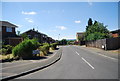
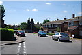
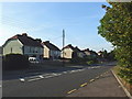
1
Swallow Road
A housing development with roads named after birds. Oriole Road is on the left aghead.
Image: © Robin Webster
Taken: 4 Jun 2012
0.04 miles
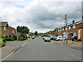
6
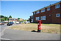
Postbox, corner of Plover Rd and Swallow Rd
Image: © N Chadwick
Taken: 10 Jul 2010
0.11 miles
9

The Old Rectory
This is probably the oldest building in this square. Today it is a restaurant and has a real well in the middle of the bar. Before it was taken over by the current chain, it used to be called The Chimneys - for obvious reasons!
Image: © Hywel Williams
Taken: 25 Jun 2005
0.13 miles