IMAGES TAKEN NEAR TO
Woodlands Road, AYLESFORD, ME20 6HH
Introduction
This page details the photographs taken nearby to Woodlands Road, ME20 6HH by members of the Geograph project.
The Geograph project started in 2005 with the aim of publishing, organising and preserving representative images for every square kilometre of Great Britain, Ireland and the Isle of Man.

There are currently over 7.5m images from over14,400 individuals and you can help contribute to the project by visiting https://www.geograph.org.uk
Image Map
Images are licensed for reuse under creativecommons.org/licenses/by-sa/2.0
Notes
- Clicking on the map will re-center to the selected point.
- The higher the marker number, the further away the image location is from the centre of the postcode.
Image Listing (16 Images Found)
Images are licensed for reuse under creativecommons.org/licenses/by-sa/2.0
Image
Details
Distance
1

Austins at Primrose Drive
An Austin A35 to left and A30 to right.
Image: © Oast House Archive
Taken: 7 Sep 2009
0.08 miles
2
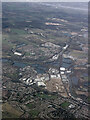
Ditton from the air
Ditton is in the foreground, with New Hythe, the River medway and the River Thames also visible.
Image: © Thomas Nugent
Taken: 28 Jan 2022
0.10 miles
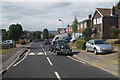
3
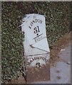
Old Milestone by the A20, London Road, Ditton parish
Metal plate attached to stone post by the A20, in parish of DITTON (TONBRIDGE AND MALLING District), London Road, by No. 476, West of TA Centre, in pavement, back to hedge, on North side of road. Kent hipped iron plate, erected by the Wrotham & Maidstone turnpike trust in the 19th century.
Inscription reads:-
: MAIDSTONE / 3 : : TO / LONDON / 31 / - / Ditton : : WROTHAM / 7 :
Carved benchmark and rivet on top.
Grade II listed.
List Entry Number: 1404161 https://historicengland.org.uk/listing/the-list/list-entry/1404161
Milestone Society National ID: KE_LF31.
Image: © C Woodward
Taken: 28 Aug 2007
0.16 miles
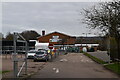
9
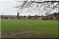
Ditton Community Centre
The large and multi-purpose Community Centre building at Ditton. For more information about Ditton parish please visit...http://www.dittonparishcouncil.gov.uk
Image: © Clive Stanley
Taken: 17 Feb 2005
0.22 miles
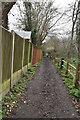
10
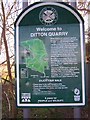
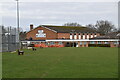
Ditton Quarry Sign
About Nature Reserve. Beside this is another sign with bi-monthly what to see notice-poster.
Image: © David Anstiss
Taken: 4 Jan 2009
0.22 miles