IMAGES TAKEN NEAR TO
New Hythe Lane, AYLESFORD, ME20 6FF
Introduction
This page details the photographs taken nearby to New Hythe Lane, ME20 6FF by members of the Geograph project.
The Geograph project started in 2005 with the aim of publishing, organising and preserving representative images for every square kilometre of Great Britain, Ireland and the Isle of Man.

There are currently over 7.5m images from over14,400 individuals and you can help contribute to the project by visiting https://www.geograph.org.uk
Image Map
Images are licensed for reuse under creativecommons.org/licenses/by-sa/2.0
Notes
- Clicking on the map will re-center to the selected point.
- The higher the marker number, the further away the image location is from the centre of the postcode.
Image Listing (36 Images Found)
Images are licensed for reuse under creativecommons.org/licenses/by-sa/2.0
Image
Details
Distance
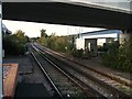
1
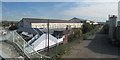
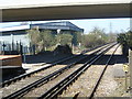
New Hythe Lane, New Hythe
Looking towards the former level crossing which was replaced by a bridge.
Image: © Chris Whippet
Taken: 21 Jul 2013
0.02 miles
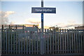
3
New Hythe railway station, Kent
Opened in 1929 by the Southern Railway on its line from Strood to Paddock Wood. View north west towards Strood. The plant on the right of the image had apparently just been demolished.
Image: © Nigel Thompson
Taken: 16 Nov 2012
0.03 miles
4
New Hythe Station and Industrial Buildings
Image: © Oast House Archive
Taken: 29 Sep 2009
0.04 miles
5
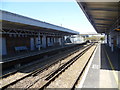
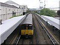
New Hythe station
The Medway Valley Line was built in two stages by the South Eastern Railway. The first stage opened in 1844 was from Paddock Wood following the Medway Valley to Maidstone. In 1856 the line was extended down the Medway Valley to the North Kent Line at Strood (which had opened in 1847). However, no trains called at New Hythe until 9th December 1929, when New Hythe Halt, a timber-built halt, was opened to serve the huge paper mill complex which had been established beside the line. The present, more substantial station on the northbound platform was constructed in 1936, but was closed in September 1989 and subsequently became derelict. This is the view from the Tonbridge-bound platform looking towards Strood.
Image: © Marathon
Taken: 23 Apr 2013
0.04 miles
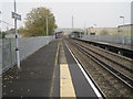
6
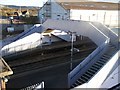
New Hythe Railway Station Footbridge
Seen from New Hythe Lane roadbridge over railway. Footbridge connects the two platforms. Platform on north side leads to Maidstone, south side platform leads to Strood.
Image: © David Anstiss
Taken: 21 Dec 2008
0.04 miles
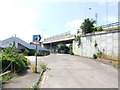
7
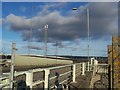
Mobile Phone Mast near New Hythe Lane
New Hythe Lane is road bridge over railway leading to various factories.
Image: © David Anstiss
Taken: 21 Dec 2008
0.04 miles
8
View from the end of the platform at New Hythe station
The Medway Valley Line was built in two stages by the South Eastern Railway. The first stage opened in 1844 was from Paddock Wood following the Medway Valley to Maidstone. In 1856 the line was extended down the Medway Valley to the North Kent Line at Strood (which had opened in 1847). However, no trains called at New Hythe until 9th December 1929, when New Hythe Halt, a timber-built halt, was opened to serve the huge paper mill complex which had been established beside the line. The present, more substantial station on the northbound platform was constructed in 1936, but was closed in September 1989 and subsequently became derelict. This is the view from the end of the Tonbridge-bound platform looking towards Strood under the bridge which carries New Hythe Lane over the railway.
Image: © Marathon
Taken: 23 Apr 2013
0.04 miles
9
New Hythe Station
New Hythe station can be seen surrounded by paper mills, which occupy the majority of this square.
Image: © Hywel Williams
Taken: 25 Jun 2005
0.05 miles