IMAGES TAKEN NEAR TO
Medina Road, AYLESFORD, ME20 6DN
Introduction
This page details the photographs taken nearby to Medina Road, ME20 6DN by members of the Geograph project.
The Geograph project started in 2005 with the aim of publishing, organising and preserving representative images for every square kilometre of Great Britain, Ireland and the Isle of Man.

There are currently over 7.5m images from over14,400 individuals and you can help contribute to the project by visiting https://www.geograph.org.uk
Image Map
Images are licensed for reuse under creativecommons.org/licenses/by-sa/2.0
Notes
- Clicking on the map will re-center to the selected point.
- The higher the marker number, the further away the image location is from the centre of the postcode.
Image Listing (22 Images Found)
Images are licensed for reuse under creativecommons.org/licenses/by-sa/2.0
Image
Details
Distance
1
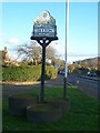
Ditton Village Sign
On green, made by Station Road meeting A20 London Road.
Looking down London Road towards Maidstone.
Image: © David Anstiss
Taken: 21 Dec 2008
0.04 miles
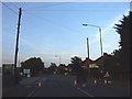
2

The A20 at the junction of Station Road, Ditton
Image: © David Howard
Taken: 21 Apr 2013
0.06 miles
3

Ditton War Memorial
On junction of A20 London Road and New Road.
Image: © David Anstiss
Taken: 21 Dec 2008
0.06 miles
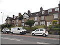
5

Row of houses on London Road, Ditton
It hasn't changed http://www.geograph.org.uk/photo/5010051
Image: © David Howard
Taken: 19 Mar 2017
0.10 miles
6
Row of houses on London Road, Ditton
I will park this reference to Ditton here
http://radondoran.tumblr.com/post/60984577048/so-i-downloaded-this-eighteenth-century-song
Image: © David Howard
Taken: 19 Jun 2016
0.10 miles

8
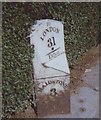
Old Milestone by the A20, London Road, Ditton parish
Metal plate attached to stone post by the A20, in parish of DITTON (TONBRIDGE AND MALLING District), London Road, by No. 476, West of TA Centre, in pavement, back to hedge, on North side of road. Kent hipped iron plate, erected by the Wrotham & Maidstone turnpike trust in the 19th century.
Inscription reads:-
: MAIDSTONE / 3 : : TO / LONDON / 31 / - / Ditton : : WROTHAM / 7 :
Carved benchmark and rivet on top.
Grade II listed.
List Entry Number: 1404161 https://historicengland.org.uk/listing/the-list/list-entry/1404161
Milestone Society National ID: KE_LF31.
Image: © C Woodward
Taken: 28 Aug 2007
0.12 miles
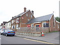
9
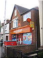
Post Office, Ditton, Kent
on New Road.
Image: © Rodney Burton
Taken: 23 Jun 2006
0.13 miles