IMAGES TAKEN NEAR TO
London Road, AYLESFORD, ME20 6DJ
Introduction
This page details the photographs taken nearby to London Road, ME20 6DJ by members of the Geograph project.
The Geograph project started in 2005 with the aim of publishing, organising and preserving representative images for every square kilometre of Great Britain, Ireland and the Isle of Man.

There are currently over 7.5m images from over14,400 individuals and you can help contribute to the project by visiting https://www.geograph.org.uk
Image Map
Images are licensed for reuse under creativecommons.org/licenses/by-sa/2.0
Notes
- Clicking on the map will re-center to the selected point.
- The higher the marker number, the further away the image location is from the centre of the postcode.
Image Listing (23 Images Found)
Images are licensed for reuse under creativecommons.org/licenses/by-sa/2.0
Image
Details
Distance
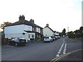
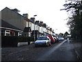
3
Stream Road Ditton
Probably the oldest part of Ditton. The bollards closed the ford across the stream several years ago and each of the ends are now overgrown.
Image: © Ron Lee
Taken: 27 Sep 2016
0.13 miles
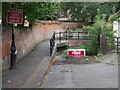
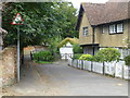
6
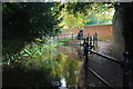
Ditton Ford
This ford is found on 'The Stream' a road leading from New Road to Bradbourne Lane. The ford has been closed by bollards at each end. The photograph is taken from within the ford.
Image: © John Walton
Taken: 8 Nov 2013
0.17 miles