
IMAGES TAKEN NEAR TO
Station Approach, Swan Street, WEST MALLING, ME19 6TT
Introduction
This page details the photographs taken nearby to Station Approach, Swan Street, ME19 6TT by members of the Geograph project.
The Geograph project started in 2005 with the aim of publishing, organising and preserving representative images for every square kilometre of Great Britain, Ireland and the Isle of Man.

There are currently over 7.5m images from over14,400 individuals and you can help contribute to the project by visiting https://www.geograph.org.uk
Image Map
Images are licensed for reuse under creativecommons.org/licenses/by-sa/2.0
Notes
- Clicking on the map will re-center to the selected point.
- The higher the marker number, the further away the image location is from the centre of the postcode.
Image Listing (39 Images Found)
Images are licensed for reuse under creativecommons.org/licenses/by-sa/2.0
Image
Details
Distance
1
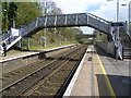
The footbridge at West Malling for Kings Hill station
The line from Otford to Maidstone East was opened on 1st June 1874 by the London, Chatham & Dover Railway. West Malling station was opened on the same day. In the 1990s it was renamed as West Malling for Kings Hill, after the development at Kings Hill on the site of the former RAF West Malling. This is the view from the up platform looking towards the footbridge and in the direction of Maidstone East.
Image: © Marathon
Taken: 27 Apr 2013
0.01 miles
2
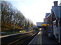
A winter's morning at West Malling for Kings Hill station
The line from Otford to Maidstone East was opened on 1st June 1874 by the London, Chatham & Dover Railway. West Malling station was opened on the same day. In the 1990s it was renamed as West Malling for Kings Hill, after the development at Kings Hill on the site of the former RAF West Malling. This is the view from the up platform looking towards the footbridge and in the direction of Maidstone East. The original impressive station buildings are on the right.
This had been a morning with a very heavy frost and the sun was just starting to melt it.
Image: © Marathon
Taken: 12 Jan 2014
0.02 miles
3
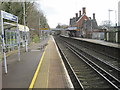
West Malling railway station, Kent
Opened in 1874 by the London Chatham & Dover Railway on the line from Swanley to Ashford (Kent).
View south east towards East Malling and Ashford. The full cumbersome title at the time this image was taken, was "West Malling for Kings Hill".
Image: © Nigel Thompson
Taken: 25 Jan 2014
0.02 miles
4
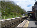
West Malling for Kings Hill station
The line from Otford to Maidstone East was opened on 1st June 1874 by the London, Chatham & Dover Railway. West Malling station was opened on the same day. In the 1990s it was renamed as West Malling for Kings Hill, after the development at Kings Hill on the site of the former RAF West Malling. This is the view from the up platform looking towards the footbridge and in the direction of Maidstone East. The original impressive station buildings are on the right.
Image: © Marathon
Taken: 27 Apr 2013
0.02 miles
5
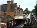
West Malling Station
West Malling station, with a london bound train just leaving the platform
Image: © Hywel Williams
Taken: 26 Jul 2005
0.03 miles
10
West Malling bypass bridge over Lucks Hill
Image: © N Chadwick
Taken: 10 Jul 2010
0.11 miles