IMAGES TAKEN NEAR TO
High Street, WEST MALLING, ME19 6NA
Introduction
This page details the photographs taken nearby to High Street, ME19 6NA by members of the Geograph project.
The Geograph project started in 2005 with the aim of publishing, organising and preserving representative images for every square kilometre of Great Britain, Ireland and the Isle of Man.

There are currently over 7.5m images from over14,400 individuals and you can help contribute to the project by visiting https://www.geograph.org.uk
Image Map
Images are licensed for reuse under creativecommons.org/licenses/by-sa/2.0
Notes
- Clicking on the map will re-center to the selected point.
- The higher the marker number, the further away the image location is from the centre of the postcode.
Image Listing (160 Images Found)
Images are licensed for reuse under creativecommons.org/licenses/by-sa/2.0
Image
Details
Distance
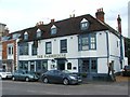
3
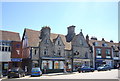
Huntsman, High St
A Grade II listed building. http://www.britishlistedbuildings.co.uk/en-392356-huntsman-91-west-malling
Image: © N Chadwick
Taken: 10 Jul 2010
0.02 miles
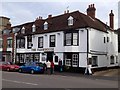
4
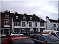
The Farm House Public House. High Street, West Malling
An Elizabethan House now houses this pub in the High Street.
Image: © PAUL FARMER
Taken: 13 Mar 2010
0.02 miles
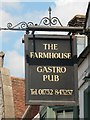
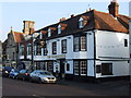
7
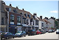
The Farmhouse, High St
Formerly The Bear Hotel, this is an 18th century coaching inn, now a gastro pub. A Grade II listed building.
Image: © N Chadwick
Taken: 10 Jul 2010
0.03 miles