IMAGES TAKEN NEAR TO
Well Street, WEST MALLING, ME19 6JP
Introduction
This page details the photographs taken nearby to Well Street, ME19 6JP by members of the Geograph project.
The Geograph project started in 2005 with the aim of publishing, organising and preserving representative images for every square kilometre of Great Britain, Ireland and the Isle of Man.

There are currently over 7.5m images from over14,400 individuals and you can help contribute to the project by visiting https://www.geograph.org.uk
Image Map
Images are licensed for reuse under creativecommons.org/licenses/by-sa/2.0
Notes
- Clicking on the map will re-center to the selected point.
- The higher the marker number, the further away the image location is from the centre of the postcode.
Image Listing (52 Images Found)
Images are licensed for reuse under creativecommons.org/licenses/by-sa/2.0
Image
Details
Distance
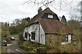
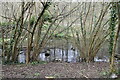
1

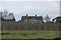
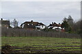
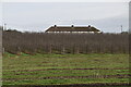
Stone-built cottages at Well Street
Built of big angular blocks of Kentish ragstone.
Were these built as estate cottages? The elevation facing the road is rather more 'architectural' than you'd expect in a humble row of farm cottages - symmetrical around a central gable, hinting at something much grander: http://www.geograph.org.uk/photo/3051895
Image: © Stefan Czapski
Taken: 28 Sep 2017
0.01 miles