IMAGES TAKEN NEAR TO
Wateringbury Road, WEST MALLING, ME19 6JG
Introduction
This page details the photographs taken nearby to Wateringbury Road, ME19 6JG by members of the Geograph project.
The Geograph project started in 2005 with the aim of publishing, organising and preserving representative images for every square kilometre of Great Britain, Ireland and the Isle of Man.

There are currently over 7.5m images from over14,400 individuals and you can help contribute to the project by visiting https://www.geograph.org.uk
Image Map
Images are licensed for reuse under creativecommons.org/licenses/by-sa/2.0
Notes
- Clicking on the map will re-center to the selected point.
- The higher the marker number, the further away the image location is from the centre of the postcode.
Image Listing (31 Images Found)
Images are licensed for reuse under creativecommons.org/licenses/by-sa/2.0
Image
Details
Distance
1
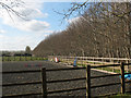
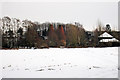
Horse exercise area
This one is at East Malling Heath. Photograph taken from the public footpath.
Image: © Stephen Craven
Taken: 22 Mar 2009
0.07 miles
2
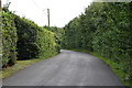
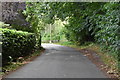
Access Lane to Hillberry Farm
Access heading east off Wateringbury Road
Image: © Chris Heaton
Taken: 13 Aug 2016
0.11 miles
3
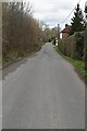
Oast House at Heath Farm, Wateringbury Road, East Malling, Kent
Image: © Oast House Archive
Taken: 4 Feb 2009
0.17 miles
6
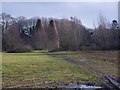
The Oast House, Heath Farm
As seen from close to the footpath from The Heath to Teston Road.
The farm behind the Oast House is on Wateringbury Road.
Image: © David Anstiss
Taken: 26 Jan 2009
0.18 miles
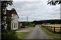
7
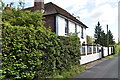
Formerly The Woodman
Now a private dwelling.
Image: © N Chadwick
Taken: 5 Sep 2019
0.18 miles
8
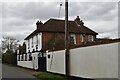
The Woodman
A former public house now a private residence.
Image: © N Chadwick
Taken: 5 Mar 2021
0.18 miles