IMAGES TAKEN NEAR TO
Sweets Lane, WEST MALLING, ME19 6JF
Introduction
This page details the photographs taken nearby to Sweets Lane, ME19 6JF by members of the Geograph project.
The Geograph project started in 2005 with the aim of publishing, organising and preserving representative images for every square kilometre of Great Britain, Ireland and the Isle of Man.

There are currently over 7.5m images from over14,400 individuals and you can help contribute to the project by visiting https://www.geograph.org.uk
Image Map
Images are licensed for reuse under creativecommons.org/licenses/by-sa/2.0
Notes
- Clicking on the map will re-center to the selected point.
- The higher the marker number, the further away the image location is from the centre of the postcode.
Image Listing (39 Images Found)
Images are licensed for reuse under creativecommons.org/licenses/by-sa/2.0
Image
Details
Distance
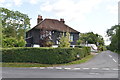
1
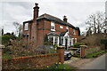
Edwardian house, Sweets Lane
Dated to 1902.
Image: © N Chadwick
Taken: 5 Mar 2021
0.01 miles
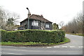
2
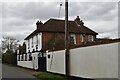
The Woodman
A former public house now a private residence.
Image: © N Chadwick
Taken: 5 Mar 2021
0.03 miles
3
Formerly The Woodman
Now a private dwelling.
Image: © N Chadwick
Taken: 5 Sep 2019
0.03 miles
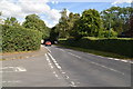
4

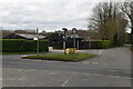
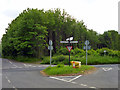
Wateringbury Road crossroads
At this crossroads Wateringbury Road meets Sweets Lane and The Heath. This is the view across Wateringbury Road to Sweets Lane.
Image: © Marathon
Taken: 11 Jul 2013
0.03 miles
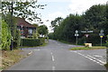
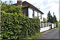
9
At the junction
The Heath meets Wateringbury Road, with Sweets Lane opposite.
Image: © Robin Webster
Taken: 4 Jun 2012
0.05 miles