IMAGES TAKEN NEAR TO
Meridian Place, WEST MALLING, ME19 6FZ
Introduction
This page details the photographs taken nearby to Meridian Place, ME19 6FZ by members of the Geograph project.
The Geograph project started in 2005 with the aim of publishing, organising and preserving representative images for every square kilometre of Great Britain, Ireland and the Isle of Man.

There are currently over 7.5m images from over14,400 individuals and you can help contribute to the project by visiting https://www.geograph.org.uk
Image Map
Images are licensed for reuse under creativecommons.org/licenses/by-sa/2.0
Notes
- Clicking on the map will re-center to the selected point.
- The higher the marker number, the further away the image location is from the centre of the postcode.
Image Listing (33 Images Found)
Images are licensed for reuse under creativecommons.org/licenses/by-sa/2.0
Image
Details
Distance
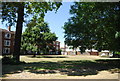
4
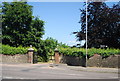
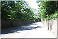
The entrance to Bradbourne House, New Rd
http://www.bradbournehousekent.co.uk/index.asp
Image: © N Chadwick
Taken: 10 Jul 2010
0.19 miles
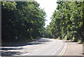
5
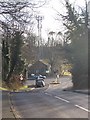
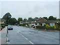
Mobile Phone Mast on traffic light junction
Lunsford Lane leads downhill to meet A20 London Road, which leads left into Maidstone via Ditton. It also leads right to Wrotham Heath. The Mast is in Kent County Council works.
Image: © David Anstiss
Taken: 27 Jan 2009
0.19 miles