IMAGES TAKEN NEAR TO
Mellinges Close, WEST MALLING, ME19 6FW
Introduction
This page details the photographs taken nearby to Mellinges Close, ME19 6FW by members of the Geograph project.
The Geograph project started in 2005 with the aim of publishing, organising and preserving representative images for every square kilometre of Great Britain, Ireland and the Isle of Man.

There are currently over 7.5m images from over14,400 individuals and you can help contribute to the project by visiting https://www.geograph.org.uk
Image Map
Images are licensed for reuse under creativecommons.org/licenses/by-sa/2.0
Notes
- Clicking on the map will re-center to the selected point.
- The higher the marker number, the further away the image location is from the centre of the postcode.
Image Listing (91 Images Found)
Images are licensed for reuse under creativecommons.org/licenses/by-sa/2.0
Image
Details
Distance
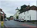
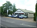
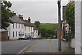
3
The road to West Malling
This view looks across London Road (A20) to Town Hill leading up to West Malling.
Image: © Marathon
Taken: 1 May 2016
0.06 miles
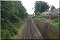
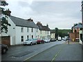
4
Townhill, West Malling
The pale green in the background are chestnut flowers.
Image: © Richard Webb
Taken: 1 Jul 2016
0.07 miles
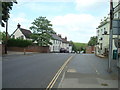
5
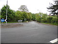
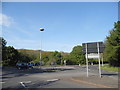
Roundabout on the A20, Leybourne
Looking towards Town Hill
Image: © David Howard
Taken: 12 May 2013
0.08 miles